This study guide is a companion for my video guide. These resources, plus the links I include, should be all you need to pass the test and get your sUAS FAA certification so you can fly drones commercially in the US.
Jacob Lamon was kind enough to save this study guide in a nicely formatted PDF – so you can continue to study on your hand-held device, even if you don’t have WiFi access. Thanks, Jacob!
Numbers
-
1. The number of drones you can fly simultaneously.
-
400 feet. The maximum height you can fly AGL or above a taller building within a 400-foot radius.
-
100 MPH/87 Knots. Fastest you can fly.
-
0.55 lbs. The lightest drone that must be registered (must be more than, not equal to, .55 lbs).
-
55 lbs. Heaviest legal drone (must be less than, not equal to, 55 lbs).
-
0.04. Maximum blood alcohol level.
-
8 hours. The time that must pass since you have had alcohol.
-
10 days. The maximum time you can take to file an FAA accident report.
-
30 days. The time you have to notify the FAA if you move.
-
90 days. The lead time required when requesting an FAA waiver.
-
1 year. Time that must pass after a final narcotics conviction.
-
13 years old. The youngest person who can register a drone.
-
24 months. How long this certification is good for.
-
30 minutes. The twilight time before sunrise or after sunset when you can still fly.
-
3 statute miles. The distance your anti-collision lights must be visible from when flying during twilight. Also the minimum visibility you must have while flying.
-
500 feet. Minimum number of feet below a cloud you must fly.
-
2,000 feet. Minimum number of feet horizontally from a cloud you must fly.
-
$500. The repair cost of accident damage that requires you to report an accident to the FAA
-
Level 3. The “serious injury” AIS level that requires you to file an accident report.
-
122.9. The MULTICOM frequency for self-announce procedures.
-
2000 feet. The distance you should operate from a tower to avoid hitting guy wires.
Facts
-
Stalls. Occurs when the wing exceeds its critical angle of attack.
-
Center of Gravity (CG) Limits. Supposed to be defined in the Pilot’s Operating Handbook or UAS Flight Manual, but those don’t exist for drones.
-
Angle of attack. Determines when the craft stalls. This doesn’t change if the vehicle weight changes.
-
Load Factor. Increases during any maneuver.
-
Remote PIC. This is the answer to any question about who is responsible.
-
Left. Aircraft always turn left when circling a runway, because drivers sit on the left side of the car in the US, and pilots sit on the left of the plane, too. It’s easier for them to look out the left window to see the tower.
-
Maintenance schedule. You’re supposed to have one, even though most drones can’t be user-repaired and don’t provide a schedule.
-
Risk Management. Helps to prevent an accident chain.
-
Personality factors.
-
Machismo. Taking risks to impress others
-
Impulsivity. Doing something without thinking about it.
-
Invulnerability. Thinking accidents won’t happen to you.
-
Resignation. What’s the use? They don’t control their destiny.
-
Anti-authority. Nobody can tell me what to do.
-
-
Crew Resource Management (CRM). It’s how you manage your “crew” and you should integrate it into all phases of the operation.
-
Systematically focus on different segments of the sky for short intervals. That’s how you should scan for traffic–let your eyes rest in different areas for a while, rather than continuously scanning.
-
Latitude is like climbing a ladder (north-south)
-
Longitude is the long way around the planet (the Earth is fat cuz it spins).
-
Standard briefing. Contains the weather forecast.
-
CTAF vs UNICOM vs MULTICOM vs AWOS. AWOS is weather. CTAF is for pilots to talk to each other when there’s no tower. UNICOM is a base station that broadcasts to pilots when there’s no tower. MULTICOM is used as the CTAF when there’s no CTAF (122.9 or 122.95).
Weather
-
Temperature inversion. Warm air on top of cold air. Fog, haze, low clouds, poor visibility, but smooth air.
-
Moist, unstable air. Turbulence (because the air is unstable), showery precipitation.
-
Stable air. Smooth air, poor visibility, and steady (not showery) precipitation (because stable air is usually humid).
-
Unstable air. Intermittent precipitation.
-
Cool + Dry = Stable
-
Hot + Humid = Unstable
-
High density altitude. Just means “high altitude”. Air is thinner, so lift is decreased.
-
Nimbus. Means a rain cloud.
METAR Reports
-
18004KT: Wind is 180 degrees at 4 knots. The first three digits (180) are the compass heading (180). The last two #s are the wind speed (04).
-
Compass headings are always relative to true North in print, not magnetic North. If it’s in print, it must be true.
-
OVC007: Sky is overcast at 700 feet. Remember, #s are always in hundreds.
-
1 1/2SM: Visibility is 1 ½ statute miles (SM).
METAR Weather Abbreviations
You don’t need to memorize these, just be able to recognize them and match them to an answer. The test will probably only use the common abbreviations.
-
BLPY Blowing spray
-
BR Mist
-
DS Dust Storm
-
DU Widespread Dust
-
DZ Drizzle
-
FC Funnel Cloud
-
+FC Tornado/Water Spout
-
FG Fog
-
FU Smoke
-
GR Hail
-
GS Small Hail/Snow Pellets
-
HZ Haze
-
IC Ice Crystals
-
PL Ice Pellets
-
PO Dust/Sand Whirls
-
RA Rain
-
SA Sand
-
SG Snow Grains
-
SN Snow
-
SQ Squall
-
SS Sandstorm
-
UP Unknown Precipitation
-
VA Volcanic Ash
CHARTS
They give you this supplement to use during the test. It has answers to most of the test questions, so don’t sweat it too much.
-
CTAF (Common Traffic Advisory Frequency) is marked with a C.
-
AWOS is for the weather.
-
Red flags mark VFR checkpoints which mean more planes might be there.
-
Tick marks. Measure minutes between latitude and longitude degrees. Each tick is one minute. Bigger ticks mark 5 minutes.
-
Charts include measurements AGL, not MSL.
Controlled Airspace
Class B is the most restricted, class E is the least restricted. Must get ATC (Air Traffic Control) authorization for class B, C, and D.
-
Class A. From 18,000 feet to 60,000 feet, all over the US.
-
Class B. Surrounding major airports, 0-10,000 feet. Consists of multiple layers, like an upside-down wedding cake.
-
Class C. Surrounding airports with a control tower, radar, and over a specific amount of traffic. Usually 5 NM (nautical mile) radius from 0-4,000 feet, and a 10 NM radius from 1,200-4,000 feet.
-
Class D. Surrounding airports with a control tower. 0-2,500 feet, no specific radius, just shaped around flight patterns. Outside control tower hours, Class D airspace is Class G.
-
Class E. Usually it starts at 1,200 feet and goes up to 18,000 feet.
-
Class G. Uncontrolled airspace (below class E airspace).
Special Use Airspace
Airspace with various restrictions.
-
Prohibited Areas (P-###). Places like Camp David and the White House.
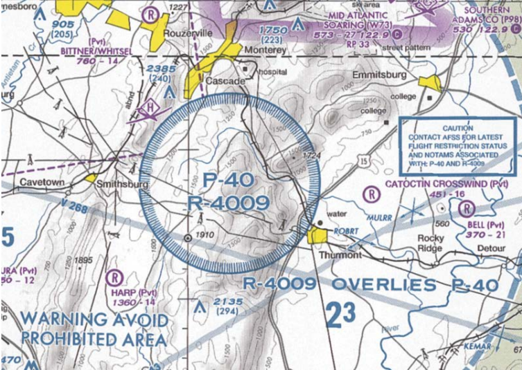
-
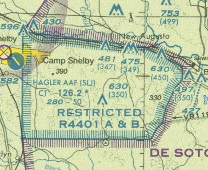
Restricted Areas (R-###). It’s not prohibited, but if you fly here, it could be dangerous. The government might be testing artillery or missiles or UFOs.
-
Warning Areas (W-###). Domestic and international waters, from NM outward from the US coast. It’s cool to fly there it’s just not really managed by the US.
-
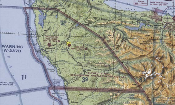
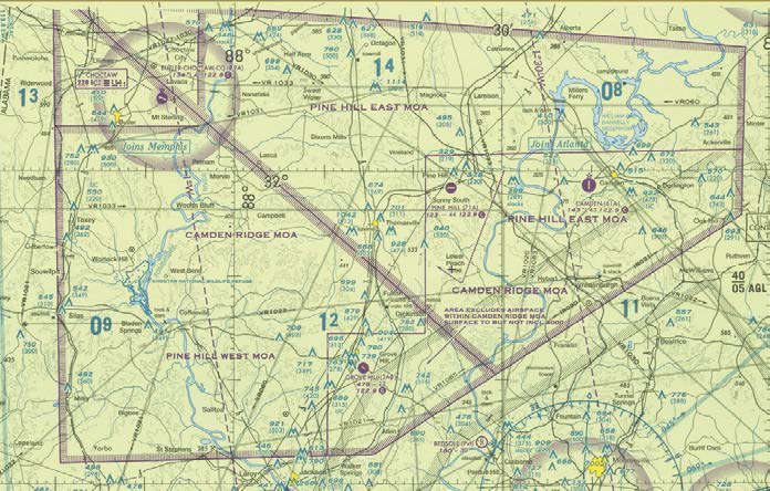
Military Operations Areas (MOAs). MOAs consist of airspace with defined limits established for the purpose of separating certain military training activities from IFR traffic. Whenever an MOA is being used, nonparticipating IFR traffic may be cleared through an MOA if IFR separation can be provided by ATC. Otherwise, ATC reroutes or restricts nonparticipating IFR traffic. Will often consist of multiple Restricted Areas (R-###). An example of this is Chocolate Mountain Impact Area (R-2507) and Chocolate Mountain Aerial Gunnery Range (R-2507), which we drove through in California.
-
Alert Areas. Depicted on aeronautical charts with an “A” followed by a number (e.g., A-211) to inform nonparticipating pilots of areas that may contain a high volume of pilot training or an unusual type of aerial activity. Think skydiving training facility.
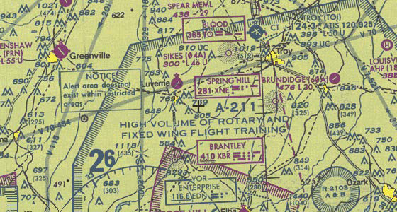
Chart-Reading Tips
-
Numbers (like 41/12) are written in 100s of feet above sea level (MSL). So, 41/12 means 4100 ft, 1200 ft. SFC = Surface
-
Helpful video: Airspace visualizations
-
Helpful video: Reading FAA charts
TAF & METAR Decoding
Acronyms
This is just for reference while you’re studying, you don’t need to memorize these.
-
AC: Advisory Circulars
-
ADM: Aeronautical Decision Making
-
AFM: Aircraft Flight Manual
-
AGL: Above Ground Level
-
AIM: Aeronautical Information Manual
-
AIS: Abbreviated Injury Scale
-
ASL: Above Sea Level
-
ASOS: Automated Surface Observing System (monitors the weather)
-
ATC: Air Traffic Control
-
ATCT: Air Traffic Control Tower
-
ATIS: Automatic Terminal Information System (a loop of useful information broadcast over the radio near an airport)
-
AWC: Aviation Weather Center
-
AWOS: Automated Weather Observing System
-
CFR: Code of Federal Regulations
-
CG: Center of Gravity
-
CoW: Certificate of Waiver
-
CRM: Crew Resource Management
-
CS: Control Station (your remote control)
-
CTAF: Common Traffic Advisory Frequency
-
FAA: Federal Aviation Administration
-
FDC: Flight Data Center
-
FLIP: Department of Defense Flight Information Publication
-
FL: Flight Level
-
FSS: Flight Service Station. Provides pilot briefings, enroute communications, search-and-rescue services, help lost aircraft, etc.
-
FTP: Flight Termination Point
-
IFR: Instrument Flight Rules
-
ILS: Instrument Landing System
-
LOA: Letter of Agreement
-
METAR: Aviation Routine Weather Reports
-
MOA: Military Operations Area
-
MSL: Mean Sea Level
-
MTR: Military Training Routes
-
MULTICOM: Not an acronym, just the radio frequency (122.9) we use to announce aircraft when there’s no ATC.
-
NAS: National Airspace System
-
NM: Nautical Miles
-
NOTAM: Notice to Airman
-
NTAP: Notice to Airman Publication
-
NTSB: National Transportation Safety Board
-
NWS: National Weather Service
-
OVC: Overcast (from METAR)
-
PIC: Pilot In Control. You, flying the drone.
-
POH: Pilot Operating Handbook
-
RA: Rain
-
SFC: Surface
-
SIDA: Secure Identification Display Area. The part of the airport where you need to be wearing a badge.
-
SM: Statute Miles
-
SMS: Safety Management System
-
sUAS: Small Unmanned Aircraft Systems (aka., drone, UA, UAS)
-
TAF: Terminal Aerodrome Forecast
-
TFR: Temporary Flight Restriction
-
UA: Unmanned Aircraft (aka., drone, sUAS, UAS)
-
UAS: Unmanned Aircraft System (aka., drone, sUAS, UA)
-
UNICOM: Not an acronym: Universal Communications. A radio broadcast that tells you about non-flight services, such as fuel, taxis, and car rentals.
-
VFR: Visual Flight Rules
-
VLOS: Visual Line-of-Sight
-
VO: Visual Observer
-
VOR: Very High Frequency Omnidirectional Range. They’re navigation beacons.
-
VR: Visual Flight Rules Military Training Routes
Free Practice Tests
-
Rupprecht Law’s sample test. Also includes detailed explanations.
Taking the Test
When you’re ready to take the test, call the test coordinator, not the testing center. The FAA lists two services. I used CATS:
-
Computer Assisted Testing Service (CATS): 1-800-947-4228
-
PSI / LaserGrade Computer Testing: 1-800-211-2753
When you call them, the process is:
-
You give your name, birth date, birth location, address, etc.
-
You tell them when and where you want to take the test.
-
They call the testing center, which is probably some small office located next to a small airport. They need to talk to the actual proctor who administers the test, so if they’re on vacation, you can’t schedule your test. I called twice to schedule a test at my closest testing center, but the proctor wasn’t personally available either time, so I gave up and scheduled my test further away at a center where the proctor actually answered the phone.
-
They charge your credit card $150.
-
They confirm your testing time and send you an email with the testing location and details.
You’ll get about 60 questions on your test. My test had 64, but it’s possible that 4 of those questions were ungraded questions that were added to my test to see if they were meaningful questions.
You need 70% to pass, so you can miss about 18 questions and still pass. All questions are multiple choice with three options (A, B, C) so even if you have to guess, you have a 33% chance of getting it correct.
Therefore, statistically, you can probably still pass if you have to guess on 27/60 questions.
However, of the three possible answers, one of them can almost always be quickly eliminated as a possible option because the answer is just stupid. Therefore, if you are unsure about a question, use logic to eliminate one of the answers, and give yourself a 50/50 chance of guessing correctly. If you can do that, you can guess at 36/60 questions and still pass.
So, you only need to be confident about 40% of the questions, and 40% of the questions are definitely really, really easy. Indeed, ~88% of testers pass, and this was the easiest certification test I’ve ever taken.
I recommend showing up to the test 30 minutes early and reviewing your notes, so the information is fresh in your mind.
Lock your phone in your car, because you can’t bring electronics into the test. Use the restroom before you go into the test, because they don’t want you to leave.
You need to bring:
-
A valid photo ID (like your driver’s license)
That’s it. The FAA tells you to bring a simple four-function calculator, but my proctor offered to loan me a calculator, and my test didn’t have any questions that required any math. So you probably don’t need to bring the calculator.
You’ll take the test in a private room sitting on an outdated computer with a dirty mouse and keyboard and a webcam pointed at you, recording everything you do. There might be other people taking tests at the same time.
Some testing tips:
-
You have two hours. That’s 2 minutes per question. It only took me about 45 minutes.
-
You can increase the font size in the testing software.
-
You can go back and change the answer to any question, until you choose to finish your test.
-
If you’re unsure about any question, take your best guess, and then click the Mark button. Marked questions show up in the index with a question mark.
-
Before you submit your final test, carefully review all your marked questions. Use the process of elimination to reduce the possible answers.
-
When you submit your test, you’ll see your score immediately. You’ll almost certainly pass it, because you’re reading this study guide, which means you’re taking it seriously and preparing… and the test is really easy.
They’ll give you some stuff to take into the test with you:
-
A pencil
-
A bunch of blank paper
-
This booklet (don’t write in it)
-
Maybe a calculator if they want to loan one to you, but they’re not required to do this
After You’ve Passed
The proctor will print out a sheet of paper with an official stamp that includes your test score, a list of the questions you missed, and a test ID. When you get back to your smartphone, take a picture of this paper, because it has the Exam ID you need and you don’t want to lose it.
YOU’RE NOT YET CERTIFIED. This is the government, so you have more paperwork to do. You need to:
-
Create an FAA account.
-
Submit an application that includes your Exam ID.
-
Wait 7 days for the FAA to email you a temporary certificate. You can now fly with that temporary certificate.
-
Wait longer for the TSA to do a background check on you and mail you your official certificate.
Wait 48 hours for the FAA to receive your test results, because even computer test results travel slower than snail mail. Don’t wait more than 10 days, however, or your test results will expire.
So, 2-10 days after you pass your test, visit http://iacra.faa.gov. Click the Register link and setup an account for yourself.
Click the Start New Application button, and fill in all the info.
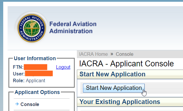
The form has a pretty weird user interface… at the bottom there are three buttons, and you’ll need to agree to terms and review a privacy agreement before you can review your application. After you review it, you need to officially submit it. It would be easy to think you were done submitting the form without actually submitting it, so be sure you actually submit it.
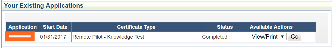
When you’re done, your FAA Applicant Console should look like this:
YOU’RE NOT YET CERTIFIED. You can’t legally fly commercially until they email you a temporary certificate.
What if you Fail
Before you leave the testing center, you can take a few minutes to review the questions you got wrong… not the answers, but the questions. Do that so you know what to study up on.
The testing center also gives you a paper listing every question you got wrong. The codes look like PLT124, PLT161, PLT173. You can look up what the codes mean here and link to the official FAA documentation for every question, which should have the answers you’re looking for (and WAY more). They don’t give you the actual question, but just the area of knowledge.
You can take the test in another two weeks… you’ll have to pay the $150 fee again, however.
One More Thing…
We’re giving away this study guide and video training material, but it definitely wasn’t free for us to make. To help us out, you could:
-
Subscribe to our YouTube channel. Visit that link and click Subscribe. It’s free, and we bring you several new drone & photography videos every week.
-
Watch our free drone videos. We teach you how to safely fly a drone, how to use cool 3D mapping software, and give you drone reviews to pick the best UAS.
-
Check out our photography & post-processing video books (at Amazon or our store). They’re $10, and watching/reading them will do WAY more to improve your aerial imagery than any hardware upgrade.
And please share this with your friends! Good luck!